Two seemingly contradictory things are expected to happen more frequently as the world continues to warm: There will be longer, more severe droughts — and there will be bigger storms that produce more precipitation.
The science isn’t that complicated. Warmer air helps water evaporate more quickly, and it means that precipitation is more likely to fall as rain than snow, reducing snow packs that help prevent or ameliorate drought. But warmer air also holds more moisture, so rainstorms will drop more rain and snowstorms more snow.
In general, these effects will happen in different places. Wetter places will be wetter still; drier places will become more dry. But then we have the state of California, where a lengthy drought is suddenly being replaced by a series of torrential rainstorms.
It’s tricky, particularly in the moment, to attribute isolated weather events to climate change. But the whipsaw experienced in California offers a preview of what scientists figure climate change will look like.
The U.S. Drought Monitor assesses the level of drought across the United States at any given time. Over the course of the past 12 months, about 90 percent of the state has been experiencing severe drought or worse in any given week on average. For five months, at least an eighth of the state was experiencing “exceptional” drought, according to the Drought Monitor’s analysis, the most significant level of drought it measures.
The most recent map of California shows that the exceptional drought has faded, though a huge portion of the state was still experiencing severe or extreme drought shortly after the new year.
Much of the region that’s in the darkest red, incidentally, overlaps with California’s Central Valley, the region of the state that is most heavily agricultural. This despite a series of heavy storms at the end of December. San Francisco, for example saw nearly a foot of rain last month, including more than 5 inches on New Year’s Eve.
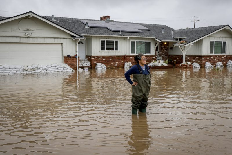
Then a new series of storms arrived, bringing another enormous amount of rain. In southern California, 24-hour rain totals often tallied more than an inch — or two, or three — in the 24-hour period before Tuesday morning.
In some places, the total was far higher. Zach Eilon of the University of California Santa Barbara noted that the amount of rain that had fallen from the beginning to the end of the day on Monday was equal to more than a third of the rain that falls in Santa Barbara over a given year.
The cause of all of this precipitation is a phenomenon called an “atmospheric river.” The evocative name is intentional, as ABC News recently explained: It’s as though there’s a river in the sky pulling moisture from tropical regions to other places. And, as you might expect, increased moisture in warmer air makes these rivers more significant.
There is one bit of good news: California’s reservoirs are adding water rapidly. Between early December and this week, data from the California Department of Water Resources shows that 17 of the state’s largest reservoirs went from an average of 62 percent of historic water levels to 83 percent. One reservoir was at or over historic levels in December; five are now.
But 12 are not. The lengthy drought that preceded the recent storms ensured that reservoir levels were remarkably low; the massive storms haven’t yet made up the entire difference. Meaning that, should the state dry out again, it may face now-familiar water resource limitations this summer.
California has bounced from one extreme to the other in a remarkably short period of time, twin weather extremes that are leading to economic hardship and widespread damage. What climate science suggests, though, is that these extremes will become more familiar in coming decades, thanks to the effects of the warming climate.